We hope that you will still join us out on the water for some of our special event paddles, fitness and yoga classes, or SUP/dinner combos. But if you have your own gear and are just looking to get out for a bit, let us help you find the right location. In this blog post, we'll focus on Hamblin Pond in Mashpee. This is a frequent location for SUP tours and lessons for a few reasons. Parking is free and close by regardless of whether you have a resident sticker or not, the water is calm and currents in the river are not too bad, although launching close to slack tide is optimal (but not necessary). If you've already done this paddle route, feel free to leave a comment below and tell everyone how it went.
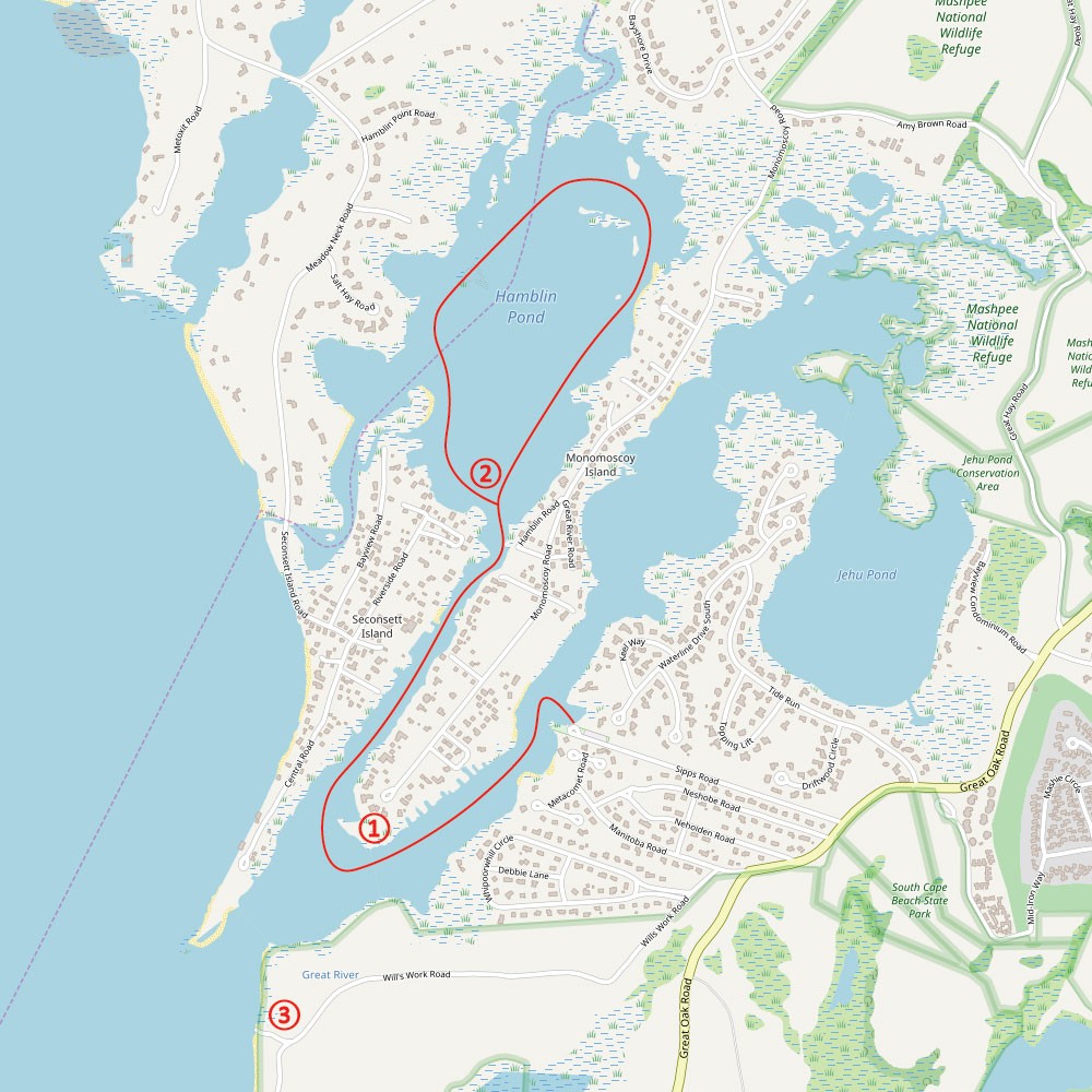
Map © Open Street Map Contributors / CC BY-SA 2.0
Total Length: 3.6 miles
Estimated Time: 1.5 hours
Type of trip: Out and back
Best launch time: 2 hours before high tide for Waquoit Bay
Maps: Click HERE for Google Map link that you can follow with your smartphone GPS
Portage: None
Parking: Free in parking lot with Mashpee Recreation sticker July 1st - Labor Day. Otherwise you may park on the road leading to the launch site.
Nearby restaurants and bars: Bobby Byrne’s or The Lanes, both at Mashpee Commons
Route Description
Launch from the Waquoit Public Landing located on Great Oak Road. If you do not have a Mashpee Beach Sticker during the summer months, you will have to park on the road leading into the parking lot. From the launch, follow Great River left/southwest through the mooring field until you get to the point of Monomoscoy Island. This is a narrow river and has considerable boat traffic in the summer, so make sure to paddle in the mooring fields on either side of the river and stay clear of the channel. Here, you will see Little River on your right/starboard side converging with your current route (see marker "1" on map above). You will also see a green buoy labeled “G1”. Paddle around the point of the island (which is not really an island) and up Little River for 0.5 miles, where it opens up into Hamblin Pond (see marker "2"). From here, you can paddle in any direction, or take the loop around the perimeter of the pond. If you have some extra time and brought a lunch, you can take a quick side trip to Wills Work Beach (marker "3") on your way back. Locals used to call this area “Secret Beach”, but those days are long gone. Although not as secluded as is used to be, it’s much less crowded than any of the public beaches in the area and makes for a great spot to stop, eat, and take a swim.
In the summer, the prevailing wind is from the southwest, which pushes straight up Great River and Little River. Wind speeds above 10 mph will make it difficult to paddle from the get-go, so make sure to check the weather prior to launch.

Gregg Squeglia
Gregg Squeglia writes travel pieces about Cape Cod and the Islands, Boston, New England and beyond. He is the author of The Day Tripper's Guide to Martha's Vineyard and the Oak Bluffs Audio Tour. He can be found at https://knockabout.blog
Recent Comments