

We hope that you will still join us out on the water for some of our special event paddles, fitness and yoga classes, or SUP/dinner combos. But if you have your own gear and are just looking to get out for a bit, let us help you find the right location. In this blog post, we’ll focus on Popponessett Bay in Mashpee. This is a frequent location for SUP tours and lessons for a few reasons. Parking is free and close by regardless of whether you have a resident sticker or not, the water is calm and currents in the river are not too bad. However, the water at the launch in Ockway Bay gets very shallow at low tide. So best to launch at least 3 hours after low tide. If you’ve already done this paddle route, feel free to leave a comment below and tell everyone how it went.
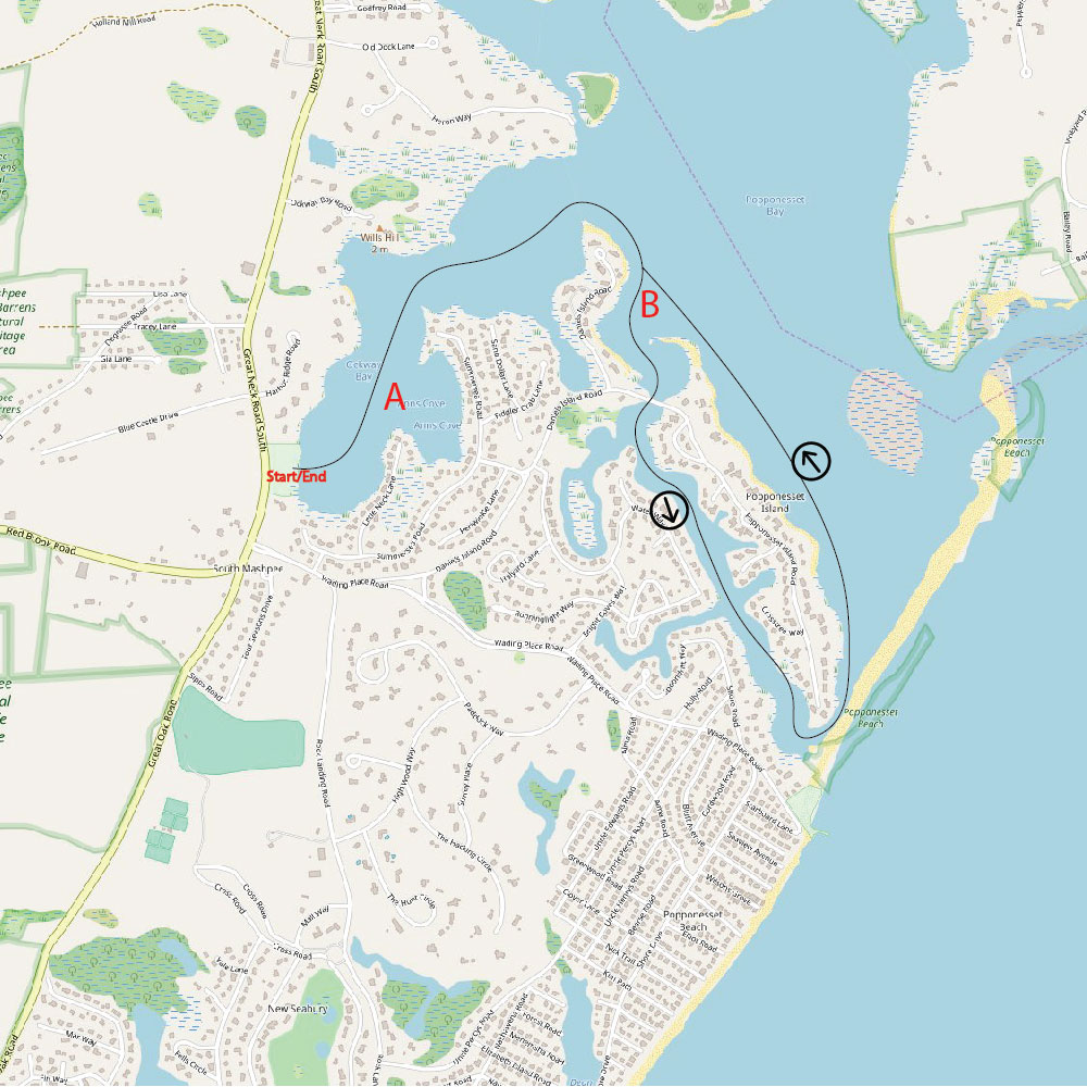
Map © Open Street Map Contributors / CC BY-SA 2.0
Total Length: 3.7 miles
Estimated Time: 2 hours
Type of trip: Loop
Best launch time: 2 hours before high tide for Popponesset Bay
Portage: None
Parking: Parking at Ockway Bay Boat Ramp. Mashpee Beach sticker required for parking lot July 1st through Labor Day. You may park on Great Neck Road opposite the launch otherwise.
Nearby restaurants and bars: Bobby Byrne’s, The Lanes, Asia, Trevi Wine Bar, all in Mashpee Commons.
ROUTE DESCRIPTION
A circumnavigation around Popponesset Island is great for paddlers of any experience level. Pay close attention to the tide on this one. Although you can get away with paddling at any tide level without having to carry your board, launching (or returning) at dead low tide might cause you to scrape your fin on the bottom in Ockway Bay (marker A), causing your board to abuptly hit the brakes and send you forward without it. You will launch at the Ockway Bay Boat Ramp located on Great Neck Road South, 3.25 miles south of the Mashpee Rotary. After putting in, head left/north through shallow Ockway Bay. Stay to the right of the yellow buoys that mark shellfish beds at milestone A. Continue until Ockway opens up to the larger Popponesset Bay. At this point the water may become a bit roughter and the wind stronger, depending on the day. As you round the corner into Popponesset, keep close to the land so you do not miss the next turn. After a few minutes of paddling, you will stay to the right and pass through a small mooring field and into the canal that separates Popponesset Island from the rest of the New Seabury development (marker B). Pass under the bridge and enjoy the calm, river-like water for the next mile. As the route opens back up into the bay, you will see the famed Popponesset Spit on your right. If you are paddling on a summer weekend, there will likely be lots of boaters anchored along the beach. This is a great place to stop and hang out for a bit. Hopefully, you brought a small cooler along for the paddle. Most of the dunes are closed off to prevent erosion, but there are a couple of passes where you can cross the dune and access the beach facing Vineyard Sound.
Gregg Squeglia writes travel pieces about Cape Cod and the Islands, Boston, New England and beyond. He is the author of The Day Tripper’s Guide to Martha’s Vineyard,the Oak Bluffs Audio Tour, and the Knockabout Guide to Boston. He can be found at https://knockabout.blog
Recent Comments